
Human Crisis Nation Against Nation Prophecy Peace Deal Talk Blackout Biological weather warfare Chemtrails Q
Climate Change Deep Unusual Earthquake Trend Volcano Trend Hurricane Trend Fireball Trend Meteor Trend Asteroid Trend
Unexplained Trends Bridge Collapsing Animal Invasion
12 hours of Earthquake Analysis
Deep earthquakes has been trending all around the world since Monday. On September 17 2018, at 00:24:15 UTC 13 hours ago near 36km ENE of Luganville, Vanuatu there was a 5.3 magnitude of 129.1 km depth. The Alaska small quakes over a few months ago are increasing in depth size such as on Monday September 17 2018, 01:16:29 UTC 137.5 km depth 12 hours ago located at 108km WSW of Talkeetna, Alaska 1.3 magnitude.
What does the deep quakes mean? Deep quakes are rear as they create cracks deep in the Earth closer to the Earth's crust. In which the spot on the ground becomes weaker.
01:33:20 UTC Valdez, Alaska
01:16:29 UTC Talkeetna, Alaska
00: 16 minutes apart
Zero depth Quake
A zero quake occurred sixteen minutes later at 1:33:20 UTC 12 hours ago Monday September 17 2018, 37km W of Valdez, Alaska 1.7 magnitude. Three minutes later, a couple of 3 magnitude quakes soon followed near the Alaska region immediately after the zero quake.
A 3.1 and a 3.0 magnitude seconds apart.
Monday September 17 2018, 01:36:02 UTC 12 hours ago 12km NE of Willow, Alaska 35.0 .
Monday September 17 2018, 01:36:01 UTC 12 hours ago 12km NE of Willow, Alaska 3.0 19.7.
Before and After
So there are deep earthquake 01:16:29 UTC 108km WSW of Talkeetna, Alaska of 137.5 km depth
before the 0 depth quake in Alaska and another deep earthquake after in Argentina San Antonio de los Cobres.
At 01:48:44 UTC 12 hours ago located at 62km WNW of San Antonio de los Cobres, Argentina a 4.3 magnitude 216.0 km depth. Could the zero depth earthquake have to do with the other deeper quakes? In order for this to be true than it must happen more than once in which in many occasions it has happened.
All of the sudden a chronological order of size in quakes began around the world. It had been quiet for a couple of hours and all of the sudden there was a trigger point. Is the zero depth quake in Alaska the trigger points.
Tonga and Russia
Tonga then had an earthquake.
Tonga and Russia are both located close to the zero quake.
(1)
02:01:42 UTC 12 hours ago South of Tonga 5.0 35.0
(2)
02:07:03 UTC 12 hours ago 59km SE of Ust'-Kamchatsk Staryy, Russia 4.3 52.9
Time Difference
2:07:03 UTC Ust'-Kamchatsk Staryy, Russia
1:33:20 UTC Alaska zero km depth
At 02:22:07 UTC another earthquake occurs in Alaska, still within the same time frame 12 hours ago 70km WNW of Skagway, Alaska 3.1 magnitude 11.3 km depth.
Twelve minutes later right after the small Alaska quake, Japan has a 5.1 magnitude of a 10 km depth at 02:32:10 UTC 11 hours ago 166km E of Nago, Japan.
At 05:47:43 UTC almost seven hours ago there was a very deep unusual earthquake in Indonesia.
Monday September 17 2018, 05:47:43 UTC 7 hours ago 104km NNW of Labuhankananga, Indonesia 4.5 magnitude 534.3 km depth.
Fiji Deep Earthquakes Continue
Yesterday there was a September 16 2018, 21:11:48 UTC South of the Fiji Islands 6.5 570.0 km depth.
577.7 km depth
Monday September 17 2018
09:32:41 UTC 6 hours ago South of the Fiji Islands 5.0 577.7
570 km depth
03:49:03 UTC 10 hours ago 174km SSW of Ndoi Island, Fiji 4.4 570.2
Deep Earthquakes in Order Today
Monday September 17 2018, 01:16:29 UTC 13 hours ago 108km WSW of Talkeetna, Alaska 1.3 137.5
Monday September 17 2018, 01:48:44 UTC 12 hours ago 62km WNW of San Antonio de los Cobres, Argentina 4.3 216.0
Monday September 17 2018, 03:49:03 UTC 10 hours ago 174km SSW of Ndoi Island, Fiji 4.4 570.2
Monday September 17 2018, 04:53:14 UTC 9 hours ago 254km SE of Vostok, Russia 4.5 156.2
Monday September 17 2018, 05:47:43 UTC 8 hours ago 104km NNW of Labuhankananga, Indonesia 4.5 534.3
Monday September 17 2018, 07:47:10 UTC 6 hours ago 76km N of Calama, Chile 4.2 109.2
Monday September 17 2018, 08:41:52 UTC 5 hours ago 68km SSW of Redoubt Volcano, Alaska 1.5 126.1
Monday September 17 2018, 09:32:41 UTC 4 hours ago South of the Fiji Islands 5.0 577.7
Monday September 17 2018, 12:35:08 UTC 113 minutes ago 80km W of Anchor Point, Alaska 4.1 109.5
How Many Zero Point form Alaska
The Zero km Alaska stop happening after 05:36:25 UTC time. There were four zero km depth quakes All in Alaska and a new one in the region of Nevada. In total within the 12 hour span there were 5 quakes with zero km depth including the Nevada. If we do not include Nevada than Alaska has had only four.
Monday September 17 2018, 01:33:20 UTC 12 hours ago 37km W of Valdez, Alaska 1.7 0.0
Monday September 17 2018, 03:26:18 UTC 11 hours ago 124km NW of Arctic Village, Alaska 1.6 0.0
Monday September 17 2018, 04:26:06 UTC 10 hours ago 50km E of Cape Yakataga, Alaska 1.4 0.1
Monday September 17 2018, 05:36:25 UTC 8 hours ago 124km NNW of Arctic Village, Alaska 1.6 0.0
New in Nevada Earthquakes Today
Monday September 17 2018
02:33:30 UTC 75km E of Beatty, Nevada 0.5 11.8 km depth
04:54:32 UTC 11km WNW of Virginia City, Nevada 0.6 1.4
07:56:49 UTC 29km SW of Hawthorne, Nevada 1.5 8.9
10:03:51 UTC 28km WSW of Hawthorne, Nevada 2.0 10.5
10:03:50 UTC 27km WSW of Hawthorne, Nevada 2.1 17.6
11:18:24 UTC 28km WSW of Hawthorne, Nevada 1.2 10.7
12:48:21 UTC 58km NNE of Beatty, Nevada 0.8 0.0
Atleast once a month Nevada has 0 depth quakes very similar to that of Alaska. They happen atleast once a month.
Monday September 17 2018, 12:48:21 UTC 100 minutes ago 58km NNE of Beatty, Nevada 0.8 0.0

Nevada has had similar quakes about a month ago 1.5 magnitude, 0 km depth on Nellis Air Force Base, Nevada, United States. Epicenter at 36.352, -114.857 21.2 km from Nellis Air Force Base (13.2 miles)
About a month ago 1.7 magnitude, 0 km depth Moapa Valley, Nevada, United States
2 months ago 1.7 magnitude, 0 km depth
Nellis Air Force Base, Nevada, United States
2 months ago 2.1 magnitude, 0 km depth
Enterprise, Nevada, United States
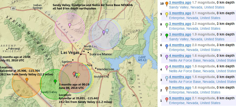
3 months ago 1.7 magnitude, 0 km depth Sandy Valley, Nevada, United States
3 months ago 2.1 magnitude, 0 km depth
Enterprise, Nevada, United States
3 months ago 2.2 magnitude, 3 km depth
Enterprise, Nevada, United States
3 months ago 1.9 magnitude, 0 km depth
Sandy Valley, Nevada, United States
4 months ago 2.0 magnitude, 3 km depth
Enterprise, Nevada, United States
4 months ago 1.6 magnitude, 0 km depth
Nellis Air Force Base, Nevada, United States
M 1.6 Explosion - 18km NE of Nellis Air Force Base, Nevada
2018-05-22 21:24:08 (UTC)36.342°N 114.890°W0.0 km depth
4 months ago 1.5 magnitude, 6 km depth
Nellis Air Force Base, Nevada, United States
4 months ago 1.5 magnitude, 0 km depth
Nellis Air Force Base, Nevada, United States
5 months ago 1.6 magnitude, 0 km depth
Enterprise, Nevada, United States
5 months ago 2.1 magnitude, 0 km depth
Enterprise, Nevada, United States
Several 0 km earthquakes coming from Alaska today is it HAARP. According to the USGS whom are the sole science agency for the Department of the Interior Website it is impossible a 0 km earthquake so why are they occurring:
An earthquake cannot physically occur at a depth of 0 km or -1km (above the surface of the earth). In order for an earthquake to occur, two blocks of crust must slip past one another, and it is impossible for this to happen at or above the surface of the earth. So why do we report that the earthquake occurred at a depth of 0 km or event as a negative depth sometimes?
First of all, the depth of an earthquake is usually the most difficult part of its location to nail down with great accuracy. Since most earthquakes are deep within the crust, an error of +/- 1 or 2 km is irrelevant; in other words, it is a small error when the depth is something like 13 km. If the earthquake depth is relatively shallow, however, it becomes more of an issue. A negative depth can sometimes be an artifact of the poor resolution for a shallow event.
For quarry blasts that are recorded by the seismic network, the depth is fixed at 0 km since we can never determine a precise depth for these, but we know they are very close to the surface.
The 0 km seem to come before deep earthquakes in fiji there may be a direct hit from HAARP.
The Fiji earthquake hits today Sunday September 16 2018, 21:11:48 UTC South of the Fiji Islands 6.5 magnitude 570.0 km deep not surprisingly the earthquake was deep. This week: 6.9 in Kermadec Islands and this month 8.2 in Levuka, Eastern, Fiji and this year an 8.2 in Levuka, Eastern, Fiji.
So far there has been M1.5 or greater 111 earthquakes in the past 24 hours. And 968 earthquakes in the past 7 days. With 4,284 earthquakes in the past 30 days and 83,215 earthquakes in the past 365 days.

When thousands of people are unable to view the public observatory telescopes on line of the Sun is this a form of Censorship or a security question. On September 6, 2018 the FBI evacuated everyone on the New Mexico Observatory. This began to make news worldwide. There were viewers that commented that Two orbs were seen on SDO satellite on September 9, 2018. So was the shut down days before a heads up of something to come.
After several days, of news blackout, reports of espionage may have solved to answer the New Mexico Observatory shut down but what about the other Countries. So one must cross out espionage worldwide.
Unexplained Trend Blackout and Censorship Solar Observation by megatrndz
Australia, Spain, Chile, Hawaii, Canada , United States and France had webcams of observatory around the world shut down or not disclosed to public. It quickly became a trend due to the fact that the observatory are telescopes around the world that is open to the public online and when that is not accessed people begin to raise concerns. Let us look at the events around the world.
One person named Alexander Mason makes an important observation:
Check out the Shecci Satellite for the 6th and 7th. Missing 7 hours of feed. Where last year on the 6th and 7th of 2017 is when the death star looking thing appeared in front of Satellite...The closed sun Observatory on 6th.
In 1961 - 1965 Garabandal, Spain apparitions of the Virgin Mary was a place where for over 2 years three young girls saw in visions the Virgin Mary over two thousands times it was recorded. In one warning of the Virgin Mary to the young one name Conchita, claiming that there will be a warning of two stars colliding with one another. But if this is to take place nervous scientists around the world is preventing human kind from being able to see what is to come. Conchita did say that we would get a warning within ourselves and God will warn us before hand.
Saturday September 16
Breaking: “Sunspot New Mexico Observatory” (Planet X Incident)
Saturday September 15
They're at it Again: Sunspot Observatory/NASA Probe/MA Fires by Lori Colley
MYSTERY IN SUNSPOT NEW MEXlCO: WHITE SANDS EVENT9,165 view
Friday September 14
6 MORE OBSERVATORIES CLOSED | WHY ALL THE EXTRA WATER? by Marfoogle News
[9.14] National Solar Observatory Evacuation Initial Analysis - What Are The Possibilities? by Destroying the Illusion
The REAL Reason For Solar Observatory Shutdown?..by Secureteam10
Wednesday September 12, 2018
Mystery Solved, National Solar Observatory Closed, Eclipse, Carrington Event by Mary Greely
New Mexico shuts down in September 6 and Hilo University Campus, Hawaii Shuts down Observatory
Possible Connection To Sunspot, New Mexico - Hawaii Observatory Camera's Are Down
#jonexarmy #sunspotobservatory #closed "Theories” why the FBI closed the National Solar Observatory! BY John X Army
Something's WRONG: National Solar Observatory EVACUATES over ‘Security Issue’ - Possible Reasons
FBI Shuts Down Sunspot Observatory by political avenger
September 13 2018
FBI Closes Sunspot Observatory, Entire Town Now Abandoned, On Scene
September 12, 2018
="https://www.youtube.com/embed/epSkXgNCHAE" width="853">
Climate Change Deep Unusual Earthquake Trend Volcano Trend Hurricane Trend Fireball Trend Meteor Trend Asteroid Trend
Unexplained Trends Bridge Collapsing Animal Invasion
Climate Chaos Deep Earthquake Trend Fiji and Indonesia
Monday 2018-09-17 8:30 am
12 hours of Earthquake Analysis
Deep earthquakes has been trending all around the world since Monday. On September 17 2018, at 00:24:15 UTC 13 hours ago near 36km ENE of Luganville, Vanuatu there was a 5.3 magnitude of 129.1 km depth. The Alaska small quakes over a few months ago are increasing in depth size such as on Monday September 17 2018, 01:16:29 UTC 137.5 km depth 12 hours ago located at 108km WSW of Talkeetna, Alaska 1.3 magnitude.
What does the deep quakes mean? Deep quakes are rear as they create cracks deep in the Earth closer to the Earth's crust. In which the spot on the ground becomes weaker.
01:33:20 UTC Valdez, Alaska
01:16:29 UTC Talkeetna, Alaska
00: 16 minutes apart
Zero depth Quake
A zero quake occurred sixteen minutes later at 1:33:20 UTC 12 hours ago Monday September 17 2018, 37km W of Valdez, Alaska 1.7 magnitude. Three minutes later, a couple of 3 magnitude quakes soon followed near the Alaska region immediately after the zero quake.
A 3.1 and a 3.0 magnitude seconds apart.
Monday September 17 2018, 01:36:02 UTC 12 hours ago 12km NE of Willow, Alaska 35.0 .
Monday September 17 2018, 01:36:01 UTC 12 hours ago 12km NE of Willow, Alaska 3.0 19.7.
Before and After
So there are deep earthquake 01:16:29 UTC 108km WSW of Talkeetna, Alaska of 137.5 km depth
before the 0 depth quake in Alaska and another deep earthquake after in Argentina San Antonio de los Cobres.
At 01:48:44 UTC 12 hours ago located at 62km WNW of San Antonio de los Cobres, Argentina a 4.3 magnitude 216.0 km depth. Could the zero depth earthquake have to do with the other deeper quakes? In order for this to be true than it must happen more than once in which in many occasions it has happened.
All of the sudden a chronological order of size in quakes began around the world. It had been quiet for a couple of hours and all of the sudden there was a trigger point. Is the zero depth quake in Alaska the trigger points.
Tonga and Russia
Tonga then had an earthquake.
Tonga and Russia are both located close to the zero quake.
(1)
02:01:42 UTC 12 hours ago South of Tonga 5.0 35.0
(2)
02:07:03 UTC 12 hours ago 59km SE of Ust'-Kamchatsk Staryy, Russia 4.3 52.9
Time Difference
2:07:03 UTC Ust'-Kamchatsk Staryy, Russia
1:33:20 UTC Alaska zero km depth
At 02:22:07 UTC another earthquake occurs in Alaska, still within the same time frame 12 hours ago 70km WNW of Skagway, Alaska 3.1 magnitude 11.3 km depth.
Twelve minutes later right after the small Alaska quake, Japan has a 5.1 magnitude of a 10 km depth at 02:32:10 UTC 11 hours ago 166km E of Nago, Japan.
At 05:47:43 UTC almost seven hours ago there was a very deep unusual earthquake in Indonesia.
Monday September 17 2018, 05:47:43 UTC 7 hours ago 104km NNW of Labuhankananga, Indonesia 4.5 magnitude 534.3 km depth.
Fiji Deep Earthquakes Continue
Yesterday there was a September 16 2018, 21:11:48 UTC South of the Fiji Islands 6.5 570.0 km depth.
577.7 km depth
Monday September 17 2018
09:32:41 UTC 6 hours ago South of the Fiji Islands 5.0 577.7
570 km depth
03:49:03 UTC 10 hours ago 174km SSW of Ndoi Island, Fiji 4.4 570.2
Deep Earthquakes in Order Today
Monday September 17 2018, 01:16:29 UTC 13 hours ago 108km WSW of Talkeetna, Alaska 1.3 137.5
Monday September 17 2018, 01:48:44 UTC 12 hours ago 62km WNW of San Antonio de los Cobres, Argentina 4.3 216.0
Monday September 17 2018, 03:49:03 UTC 10 hours ago 174km SSW of Ndoi Island, Fiji 4.4 570.2
Monday September 17 2018, 04:53:14 UTC 9 hours ago 254km SE of Vostok, Russia 4.5 156.2
Monday September 17 2018, 05:47:43 UTC 8 hours ago 104km NNW of Labuhankananga, Indonesia 4.5 534.3
Monday September 17 2018, 07:47:10 UTC 6 hours ago 76km N of Calama, Chile 4.2 109.2
Monday September 17 2018, 08:41:52 UTC 5 hours ago 68km SSW of Redoubt Volcano, Alaska 1.5 126.1
Monday September 17 2018, 09:32:41 UTC 4 hours ago South of the Fiji Islands 5.0 577.7
Monday September 17 2018, 12:35:08 UTC 113 minutes ago 80km W of Anchor Point, Alaska 4.1 109.5
How Many Zero Point form Alaska
The Zero km Alaska stop happening after 05:36:25 UTC time. There were four zero km depth quakes All in Alaska and a new one in the region of Nevada. In total within the 12 hour span there were 5 quakes with zero km depth including the Nevada. If we do not include Nevada than Alaska has had only four.
Monday September 17 2018, 01:33:20 UTC 12 hours ago 37km W of Valdez, Alaska 1.7 0.0
Monday September 17 2018, 03:26:18 UTC 11 hours ago 124km NW of Arctic Village, Alaska 1.6 0.0
Monday September 17 2018, 04:26:06 UTC 10 hours ago 50km E of Cape Yakataga, Alaska 1.4 0.1
Monday September 17 2018, 05:36:25 UTC 8 hours ago 124km NNW of Arctic Village, Alaska 1.6 0.0
New in Nevada Earthquakes Today
Monday September 17 2018
02:33:30 UTC 75km E of Beatty, Nevada 0.5 11.8 km depth
04:54:32 UTC 11km WNW of Virginia City, Nevada 0.6 1.4
07:56:49 UTC 29km SW of Hawthorne, Nevada 1.5 8.9
10:03:51 UTC 28km WSW of Hawthorne, Nevada 2.0 10.5
10:03:50 UTC 27km WSW of Hawthorne, Nevada 2.1 17.6
11:18:24 UTC 28km WSW of Hawthorne, Nevada 1.2 10.7
12:48:21 UTC 58km NNE of Beatty, Nevada 0.8 0.0
Atleast once a month Nevada has 0 depth quakes very similar to that of Alaska. They happen atleast once a month.
Monday September 17 2018, 12:48:21 UTC 100 minutes ago 58km NNE of Beatty, Nevada 0.8 0.0
Nevada has had similar quakes about a month ago 1.5 magnitude, 0 km depth on Nellis Air Force Base, Nevada, United States. Epicenter at 36.352, -114.857 21.2 km from Nellis Air Force Base (13.2 miles)
About a month ago 1.7 magnitude, 0 km depth Moapa Valley, Nevada, United States
2 months ago 1.7 magnitude, 0 km depth
Nellis Air Force Base, Nevada, United States
2 months ago 2.1 magnitude, 0 km depth
Enterprise, Nevada, United States
3 months ago 1.7 magnitude, 0 km depth Sandy Valley, Nevada, United States
3 months ago 2.1 magnitude, 0 km depth
Enterprise, Nevada, United States
3 months ago 2.2 magnitude, 3 km depth
Enterprise, Nevada, United States
3 months ago 1.9 magnitude, 0 km depth
Sandy Valley, Nevada, United States
4 months ago 2.0 magnitude, 3 km depth
Enterprise, Nevada, United States
4 months ago 1.6 magnitude, 0 km depth
Nellis Air Force Base, Nevada, United States
M 1.6 Explosion - 18km NE of Nellis Air Force Base, Nevada
2018-05-22 21:24:08 (UTC)36.342°N 114.890°W0.0 km depth
4 months ago 1.5 magnitude, 6 km depth
Nellis Air Force Base, Nevada, United States
4 months ago 1.5 magnitude, 0 km depth
Nellis Air Force Base, Nevada, United States
5 months ago 1.6 magnitude, 0 km depth
Enterprise, Nevada, United States
5 months ago 2.1 magnitude, 0 km depth
Enterprise, Nevada, United States
Climate Chaos Deep Earthquake Trend Fiji 6.5 Magnitude
Sunday 2018-09-16
An earthquake cannot physically occur at a depth of 0 km or -1km (above the surface of the earth). In order for an earthquake to occur, two blocks of crust must slip past one another, and it is impossible for this to happen at or above the surface of the earth. So why do we report that the earthquake occurred at a depth of 0 km or event as a negative depth sometimes?
First of all, the depth of an earthquake is usually the most difficult part of its location to nail down with great accuracy. Since most earthquakes are deep within the crust, an error of +/- 1 or 2 km is irrelevant; in other words, it is a small error when the depth is something like 13 km. If the earthquake depth is relatively shallow, however, it becomes more of an issue. A negative depth can sometimes be an artifact of the poor resolution for a shallow event.
For quarry blasts that are recorded by the seismic network, the depth is fixed at 0 km since we can never determine a precise depth for these, but we know they are very close to the surface.
The 0 km seem to come before deep earthquakes in fiji there may be a direct hit from HAARP.
The Fiji earthquake hits today Sunday September 16 2018, 21:11:48 UTC South of the Fiji Islands 6.5 magnitude 570.0 km deep not surprisingly the earthquake was deep. This week: 6.9 in Kermadec Islands and this month 8.2 in Levuka, Eastern, Fiji and this year an 8.2 in Levuka, Eastern, Fiji.
So far there has been M1.5 or greater 111 earthquakes in the past 24 hours. And 968 earthquakes in the past 7 days. With 4,284 earthquakes in the past 30 days and 83,215 earthquakes in the past 365 days.
| DATE/TIME | REGION | MAGNITUDE | DEPTH (in km) | SOURCE | DETAIL | ||
| Monday September 17 2018, 01:22:29 UTC | 13 minutes ago | 9km ENE of Aguanga, CA |  | 1.0 | 4.7 | USGS Feed | Detail |
| Monday September 17 2018, 01:22:29 UTC | 13 minutes ago | 9km ENE of Aguanga, CA | | 1.0 | 4.7 | USGS Feed | Detail |
| Monday September 17 2018, 01:17:08 UTC | 19 minutes ago | 23km ENE of Pine Valley, CA | | 1.2 | 8.6 | USGS Feed | Detail |
| Monday September 17 2018, 01:02:05 UTC | 34 minutes ago | 23km NE of Pine Valley, CA | | 1.1 | 6.1 | USGS Feed | Detail |
| Monday September 17 2018, 00:59:57 UTC | 36 minutes ago | 19km E of Julian, CA | | 1.1 | 12.8 | USGS Feed | Detail |
| Monday September 17 2018, 00:56:14 UTC | 39 minutes ago | 10km NE of Aguanga, CA | | 0.7 | 3.7 | USGS Feed | Detail |
| Monday September 17 2018, 00:50:44 UTC | 45 minutes ago | 11km SW of Leilani Estates, Hawaii | | 2.1 | 4.8 | USGS Feed | Detail |
| Monday September 17 2018, 00:45:47 UTC | 50 minutes ago | 9km NE of Aguanga, CA | | 1.1 | 3.1 | USGS Feed | Detail |
| Monday September 17 2018, 00:24:15 UTC | 71 minutes ago | 36km ENE of Luganville, Vanuatu |  | 5.3 | 129.1 | USGS Feed | Detail |
| Monday September 17 2018, 00:24:10 UTC | 72 minutes ago | 80km SE of Makry Gialos, Greece | | 5.0 | 22.3 | USGS Feed | Detail |
| Monday September 17 2018, 00:22:32 UTC | 73 minutes ago | 29km SE of Jarm, Afghanistan | | 4.3 | 245.8 | USGS Feed | Detail |
| Monday September 17 2018, 00:08:26 UTC | 87 minutes ago | 6km WNW of Gervais, Oregon | | 2.9 | 40.0 | USGS Feed | Detail |
| Monday September 17 2018, 00:08:23 UTC | 87 minutes ago | South of the Fiji Islands | | 4.7 | 580.0 | USGS Feed | Detail |
| Sunday September 16 2018, 23:33:41 UTC | 2 hours ago | 23km ENE of Pine Valley, CA | | 0.9 | 6.3 | USGS Feed | Detail |
| Sunday September 16 2018, 23:28:09 UTC | 2 hours ago | 11km NE of Aguanga, CA | | 0.4 | 4.6 | USGS Feed | Detail |
| Sunday September 16 2018, 23:24:17 UTC | 2 hours ago | 9km NE of Aguanga, CA | | 0.9 | 6.1 | USGS Feed | Detail |
| Sunday September 16 2018, 23:18:04 UTC | 2 hours ago | 4km NNW of Boron, CA | | 1.7 | 0.3 | USGS Feed | Detail |
| Sunday September 16 2018, 23:03:07 UTC | 2 hours ago | 68km SSW of Kaktovik, Alaska | | 2.8 | 7.8 | USGS Feed | Detail |
| Sunday September 16 2018, 22:58:24 UTC | 2 hours ago | 6km NW of Palomar Observatory, CA | | 0.4 | 8.2 | USGS Feed | Detail |
| Sunday September 16 2018, 22:58:24 UTC | 2 hours ago | 6km NW of Palomar Observatory, CA | | 0.4 | 8.2 | USGS Feed | Detail |
| Sunday September 16 2018, 22:53:11 UTC | 2 hours ago | 9km NE of Aguanga, CA | | 0.7 | 5.5 | USGS Feed | Detail |
| Sunday September 16 2018, 22:47:42 UTC | 2 hours ago | 148km NNE of Vieques, Puerto Rico | | 3.4 | 40.0 | USGS Feed | Detail |
| Sunday September 16 2018, 22:09:10 UTC | 3 hours ago | 49km WSW of Anchor Point, Alaska | | 1.5 | 85.1 | USGS Feed | Detail |
| Sunday September 16 2018, 22:04:11 UTC | 3 hours ago | 3km WSW of San Juan Bautista, CA | | 2.6 | 6.0 | USGS Feed | Detail |
| Sunday September 16 2018, 22:03:03 UTC | 3 hours ago | 3km W of Cabazon, CA | | 0.7 | 0.4 | USGS Feed | Detail |
| Sunday September 16 2018, 21:41:54 UTC | 3 hours ago | 125km NNW of Arctic Village, Alaska | | 1.7 | 0.0 | USGS Feed | Detail |
| Sunday September 16 2018, 21:30:32 UTC | 4 hours ago | 114km NW of Arctic Village, Alaska | | 1.7 | 0.0 | USGS Feed | Detail |
| Sunday September 16 2018, 21:30:25 UTC | 4 hours ago | 264km SE of Kodiak, Alaska | | 4.5 | 18.9 | USGS Feed | Detail |
| Sunday September 16 2018, 21:23:42 UTC | 4 hours ago | 64km WNW of Cape Yakataga, Alaska | | 2.0 | 49.7 | USGS Feed | Detail |
| Sunday September 16 2018, 21:23:41 UTC | 4 hours ago | 11km WSW of Morton, Washington | | 2.2 | 4.6 | USGS Feed | Detail |
| Sunday September 16 2018, 21:23:05 UTC | 4 hours ago | 39km SSE of Goldfield, Nevada | | 2.2 | 3.4 | USGS Feed | Detail |
| Sunday September 16 2018, 21:22:04 UTC | 4 hours ago | 7km E of Puebla, B.C., MX | | 2.0 | 20.0 | USGS Feed | Detail |
| Sunday September 16 2018, 21:19:25 UTC | 4 hours ago | 10km NNW of Delta, B.C., MX | | 2.0 | 12.2 | USGS Feed | Detail |
| Sunday September 16 2018, 21:16:46 UTC | 4 hours ago | 1km SSW of Big Bear Lake, CA | | 1.9 | 7.1 | USGS Feed | Detail |
| Sunday September 16 2018, 21:11:48 UTC | 4 hours ago | South of the Fiji Islands | | 6.5 | 570.0 | USGS Feed | Detail |
| Sunday September 16 2018, 21:06:13 UTC | 4 hours ago | 5km SW of Volcano, Hawaii | | 1.8 | 0.6 | USGS Feed | Detail |
| Sunday September 16 2018, 21:03:10 UTC | 4 hours ago | 30km NW of Valdez, Alaska | | 1.1 | 12.5 | USGS Feed | Detail |
| Sunday September 16 2018, 20:54:09 UTC | 4 hours ago | 63km NNE of Yakutat, Alaska | | 1.4 | 0.0 | USGS Feed | Detail |
| Sunday September 16 2018, 20:52:58 UTC | 4 hours ago | 128km NW of Arctic Village, Alaska | | 2.1 | 0.0 | USGS Feed | Detail |
| Sunday September 16 2018, 20:49:58 UTC | 4 hours ago | 4km SW of Volcano, Hawaii | | 1.9 | 0.0 | USGS Feed | Detail |
| Sunday September 16 2018, 20:49:57 UTC | 4 hours ago | 4km WSW of Volcano, Hawaii | | 1.9 | 0.9 | USGS Feed | Detail |
| Sunday September 16 2018, 20:40:06 UTC | 4 hours ago | 14km NNE of Borrego Springs, CA | | 1.2 | 9.2 | USGS Feed | Detail |
| Sunday September 16 2018, 20:21:04 UTC | 5 hours ago | 95km NNW of Arctic Village, Alaska | | 2.4 | 0.0 | USGS Feed | Detail |
| Sunday September 16 2018, 20:21:04 UTC | 5 hours ago | 95km NNW of Arctic Village, Alaska | | 2.4 | 0.0 | USGS Feed | Detail |
| Sunday September 16 2018, 20:20:54 UTC | 5 hours ago | Palau region | | 4.9 | 10.0 | USGS Feed | Detail |
| Sunday September 16 2018, 20:02:28 UTC | 5 hours ago | 8km NE of Aguanga, CA | | 1.2 | 3.9 | USGS Feed | Detail |
| Sunday September 16 2018, 19:58:46 UTC | 5 hours ago | 75km N of Talkeetna, Alaska | | 1.4 | 88.3 | USGS Feed | Detail |
| Sunday September 16 2018, 19:55:25 UTC | 5 hours ago | 105km NW of Arctic Village, Alaska | | 2.5 | 0.0 | USGS Feed | Detail |
| Sunday September 16 2018, 19:47:00 UTC | 5 hours ago | 78km NW of Arctic Village, Alaska | | 1.7 | 0.9 | USGS Feed | Detail |
| Sunday September 16 2018, 19:38:23 UTC | 5 hours ago | 134km NW of Talkeetna, Alaska | | 1.9 | 0.0 | USGS Feed | Detail |
| Sunday September 16 2018, 19:33:49 UTC | 6 hours ago | 149km NW of Talkeetna, Alaska | | 3.0 | 10.2 | USGS Feed | Detail |
| Sunday September 16 2018, 19:31:00 UTC | 6 hours ago | 9km NE of Aguanga, CA | | 0.3 | 2.5 | USGS Feed | Detail |
| Sunday September 16 2018, 19:21:23 UTC | 6 hours ago | 3km E of Ridgely, Tennessee | | 2.1 | 6.5 | USGS Feed | Detail |
| Sunday September 16 2018, 19:17:20 UTC | 6 hours ago | 8km ENE of Aguanga, CA | | 1.0 | 4.0 | USGS Feed | Detail |
| Sunday September 16 2018, 19:11:54 UTC | 6 hours ago | 34km E of Tanana, Alaska | | 3.9 | 12.4 | USGS Feed | Detail |
| Sunday September 16 2018, 19:06:11 UTC | 6 hours ago | 16km ESE of Julian, CA | | 1.4 | 6.2 | USGS Feed | Detail |
| Sunday September 16 2018, 18:59:29 UTC | 6 hours ago | 47km WSW of Big Lake, Alaska | | 1.1 | 54.7 | USGS Feed | Detail |
| Sunday September 16 2018, 18:58:49 UTC | 6 hours ago | 38km W of Anchor Point, Alaska | | 1.1 | 66.3 | USGS Feed | Detail |
| Sunday September 16 2018, 18:56:47 UTC | 6 hours ago | 112km NW of Talkeetna, Alaska | | 1.3 | 0.0 | USGS Feed | Detail |
| Sunday September 16 2018, 18:56:10 UTC | 6 hours ago | 10km NE of Aguanga, CA | | 0.5 | 2.9 | USGS Feed | Detail |
| Sunday September 16 2018, 18:47:04 UTC | 6 hours ago | 8km SW of Camarillo, CA | | 1.7 | 7.7 | USGS Feed | Detail |
| Sunday September 16 2018, 18:46:55 UTC | 6 hours ago | 5km ENE of Riversdale, Jamaica | | 3.3 | 10.0 | USGS Feed | Detail |
| Sunday September 16 2018, 18:32:19 UTC | 7 hours ago | 68km SSW of Kaktovik, Alaska | | 2.4 | 1.0 | USGS Feed | Detail |
| Sunday September 16 2018, 18:17:37 UTC | 7 hours ago | 124km NW of Arctic Village, Alaska | | 1.6 | 0.0 | USGS Feed | Detail |
| Sunday September 16 2018, 17:58:09 UTC | 7 hours ago | 132km WNW of Arctic Village, Alaska | | 1.4 | 0.0 | USGS Feed | Detail |
| Sunday September 16 2018, 17:51:42 UTC | 7 hours ago | 55km NNW of San Antonio, Puerto Rico | | 2.9 | 51.0 | USGS Feed | Detail |
| Sunday September 16 2018, 17:51:29 UTC | 7 hours ago | 22km E of Tomakomai, Japan | | 4.8 | 13.5 | USGS Feed | Detail |
| Sunday September 16 2018, 17:44:49 UTC | 7 hours ago | 5km E of Yucaipa, CA | | 0.9 | 3.5 | USGS Feed | Detail |
| Sunday September 16 2018, 17:43:41 UTC | 7 hours ago | 10km NE of Aratoca, Colombia | | 4.2 | 166.9 | USGS Feed | Detail |
| Sunday September 16 2018, 17:42:51 UTC | 7 hours ago | 21km SSE of Homer, Alaska | | 1.3 | 44.4 | USGS Feed | Detail |
| Sunday September 16 2018, 17:41:30 UTC | 7 hours ago | 69km SSW of Kaktovik, Alaska | | 2.5 | 0.0 | USGS Feed | Detail |
| Sunday September 16 2018, 17:37:56 UTC | 7 hours ago | 57km NW of Cape Yakataga, Alaska | | 0.5 | 11.2 | USGS Feed | Detail |
| Sunday September 16 2018, 17:37:51 UTC | 7 hours ago | 61km NNW of Talkeetna, Alaska | | 1.6 | 83.7 | USGS Feed | Detail |
| Sunday September 16 2018, 17:37:35 UTC | 7 hours ago | 2km NE of Langston, Oklahoma | | 2.2 | 5.0 | USGS Feed | Detail |
| Sunday September 16 2018, 17:27:14 UTC | 8 hours ago | 6km NNW of Banning, CA | | 1.2 | 13.5 | USGS Feed | Detail |
| Sunday September 16 2018, 17:21:22 UTC | 8 hours ago | 10km NW of Sutton-Alpine, Alaska | | 1.3 | 23.6 | USGS Feed | Detail |
| Sunday September 16 2018, 17:14:54 UTC | 8 hours ago | 2km ENE of Studio City, CA | | 2.0 | 14.2 | USGS Feed | Detail |
| Sunday September 16 2018, 17:13:41 UTC | 8 hours ago | 10km NNE of Boulder City, Nevada | | 0.5 | 0.0 | USGS Feed | Detail |
| Sunday September 16 2018, 17:01:02 UTC | 8 hours ago | 9km NE of Aguanga, CA | | 0.6 | 5.0 | USGS Feed | Detail |
| Sunday September 16 2018, 17:00:41 UTC | 8 hours ago | 108km NW of Arctic Village, Alaska | | 1.6 | 0.0 | USGS Feed | Detail |
| Sunday September 16 2018, 16:56:33 UTC | 8 hours ago | 17km N of Snyder, Texas | | 2.8 | 1.7 | USGS Feed | Detail |
| Sunday September 16 2018, 16:46:18 UTC | 8 hours ago | 8km NE of Aguanga, CA | | 0.4 | 6.2 | USGS Feed | Detail |
| Sunday September 16 2018, 16:30:25 UTC | 9 hours ago | 66km WNW of Talkeetna, Alaska | | 1.4 | 86.9 | USGS Feed | Detail |
| Sunday September 16 2018, 16:18:11 UTC | 9 hours ago | 98km W of Talkeetna, Alaska | | 1.3 | 8.1 | USGS Feed | Detail |
| Sunday September 16 2018, 16:17:22 UTC | 9 hours ago | 75km N of Nikiski, Alaska | | 0.4 | 34.4 | USGS Feed | Detail |
| Sunday September 16 2018, 15:50:38 UTC | 9 hours ago | 9km SSE of Idyllwild, CA | | 0.9 | 15.2 | USGS Feed | Detail |
| Sunday September 16 2018, 15:39:56 UTC | 9 hours ago | 16km NNW of Borrego Springs, CA | | 1.0 | 10.6 | USGS Feed | Detail |
| Sunday September 16 2018, 15:34:22 UTC | 10 hours ago | 7km SE of Challis, Idaho | | 2.8 | 5.0 | USGS Feed | Detail |
| Sunday September 16 2018, 15:29:04 UTC | 10 hours ago | 8km ENE of Aguanga, CA | | 2.0 | 2.9 | USGS Feed | Detail |
| Sunday September 16 2018, 15:27:42 UTC | 10 hours ago | 9km NE of Aguanga, CA | | 0.3 | 2.9 | USGS Feed | Detail |
| Sunday September 16 2018, 15:23:40 UTC | 10 hours ago | 3km N of Pinnacles, CA | | 1.3 | 4.5 | USGS Feed | Detail |
| Sunday September 16 2018, 15:05:59 UTC | 10 hours ago | 5km WSW of Volcano, Hawaii | | 1.9 | 0.5 | USGS Feed | Detail |
| Sunday September 16 2018, 15:00:29 UTC | 10 hours ago | 56km NNW of Port-Olry, Vanuatu | | 5.2 | 23.7 | USGS Feed | Detail |
| Sunday September 16 2018, 14:56:10 UTC | 10 hours ago | 1km SSW of Big Bear Lake, CA | | 1.7 | 7.1 | USGS Feed | Detail |
| Sunday September 16 2018, 14:51:09 UTC | 10 hours ago | 7km ESE of Puebla, B.C., MX | | 2.1 | 16.4 | USGS Feed | Detail |
| Sunday September 16 2018, 14:49:09 UTC | 10 hours ago | 136km E of Chitina, Alaska | | 1.1 | 0.0 | USGS Feed | Detail |
| Sunday September 16 2018, 14:49:09 UTC | 10 hours ago | 64km ESE of Lazy Mountain, Alaska | | 1.3 | 28.1 | USGS Feed | Detail |
| Sunday September 16 2018, 14:44:20 UTC | 10 hours ago | 54km ENE of Cape Yakataga, Alaska | | 1.3 | 0.6 | USGS Feed | Detail |
| Sunday September 16 2018, 14:16:48 UTC | 11 hours ago | 110km W of Larsen Bay, Alaska | | 1.3 | 79.5 | USGS Feed | Detail |
| Sunday September 16 2018, 13:41:09 UTC | 11 hours ago | 30km ENE of Bridgeport, California | | 0.9 | 4.9 | USGS Feed | Detail |
Unexplained Trend Blackout and Censorship Solar Observatories Closed to Public
Saturday 2018-09-15 updated 2018-09-16
When thousands of people are unable to view the public observatory telescopes on line of the Sun is this a form of Censorship or a security question. On September 6, 2018 the FBI evacuated everyone on the New Mexico Observatory. This began to make news worldwide. There were viewers that commented that Two orbs were seen on SDO satellite on September 9, 2018. So was the shut down days before a heads up of something to come.
After several days, of news blackout, reports of espionage may have solved to answer the New Mexico Observatory shut down but what about the other Countries. So one must cross out espionage worldwide.
Unexplained Trend Blackout and Censorship Solar Observation by megatrndz
Australia, Spain, Chile, Hawaii, Canada , United States and France had webcams of observatory around the world shut down or not disclosed to public. It quickly became a trend due to the fact that the observatory are telescopes around the world that is open to the public online and when that is not accessed people begin to raise concerns. Let us look at the events around the world.
One person named Alexander Mason makes an important observation:
Check out the Shecci Satellite for the 6th and 7th. Missing 7 hours of feed. Where last year on the 6th and 7th of 2017 is when the death star looking thing appeared in front of Satellite...The closed sun Observatory on 6th.
In 1961 - 1965 Garabandal, Spain apparitions of the Virgin Mary was a place where for over 2 years three young girls saw in visions the Virgin Mary over two thousands times it was recorded. In one warning of the Virgin Mary to the young one name Conchita, claiming that there will be a warning of two stars colliding with one another. But if this is to take place nervous scientists around the world is preventing human kind from being able to see what is to come. Conchita did say that we would get a warning within ourselves and God will warn us before hand.
Saturday September 16
Breaking: “Sunspot New Mexico Observatory” (Planet X Incident)
Saturday September 15
They're at it Again: Sunspot Observatory/NASA Probe/MA Fires by Lori Colley
MYSTERY IN SUNSPOT NEW MEXlCO: WHITE SANDS EVENT9,165 view
Friday September 14
6 MORE OBSERVATORIES CLOSED | WHY ALL THE EXTRA WATER? by Marfoogle News
[9.14] National Solar Observatory Evacuation Initial Analysis - What Are The Possibilities? by Destroying the Illusion
The REAL Reason For Solar Observatory Shutdown?..by Secureteam10
Wednesday September 12, 2018
Mystery Solved, National Solar Observatory Closed, Eclipse, Carrington Event by Mary Greely
New Mexico shuts down in September 6 and Hilo University Campus, Hawaii Shuts down Observatory
Possible Connection To Sunspot, New Mexico - Hawaii Observatory Camera's Are Down
#jonexarmy #sunspotobservatory #closed "Theories” why the FBI closed the National Solar Observatory! BY John X Army
Something's WRONG: National Solar Observatory EVACUATES over ‘Security Issue’ - Possible Reasons
FBI Shuts Down Sunspot Observatory by political avenger
September 13 2018
FBI Closes Sunspot Observatory, Entire Town Now Abandoned, On Scene
September 12, 2018
="https://www.youtube.com/embed/epSkXgNCHAE" width="853">
September 11, 2018
NEWS BLACKOUT: Space Observatory Mysteriously LOCKED DOWN & Nobody...
Two Objects Eclipse Sun on SDO Satellite on 9th Part 1 by WSO
September 9, 2018
7 hours of Data Missing on all SECCHI Satellites
Does this mysterious event has to do with Revelation 12 September 23, 2017
Blue Koolaid Oh Ya published on Sep 9, 2018
Multiple hours missing on SECCHI satellites from the 6 and 7 of September. Plus huge object shows up exactly one year ago from Data missing.
Data missing on all SECCHI satellites plus huge object showed up
Hole In the Antarctica Ice
9-6-18~EVIDENCE OF SPACECRAFT LAUNCH IN ANTARCTICA(!) IMPACT FRACTURING FROM HIGH SPEED EXIT(!) BY Florida Marquis
¿Qué PASÓ en Garabandal? Documental completo. (ESPAÑOL) by Virgen Medjugorje Published on Mar 9, 2016
Climate Chaos Q Hurricane Florence, Washington Gods
Thursday 2018-09-13
September 12 was a busy day for the leaders of the weather warfare agenda. The Q trend may be a trend that some youtubers are following around the World, channels like Destroying the Illusion and Lori love to follow it as part of the social media enthusiast.
While some are believing Hurricane Florence is a naturally formed monster others are not been fooled. Deborah Tavares, Lori Colley and Project Camelot channel are among those that are not being fooled.
DEBORAH TAVARES : HURRICANE FLORENCE : WEATHER WARS PART ONE by Project Camelot
Steered and Manipulated are the warning words of Dane Wigington master of sounding the alarm of Geoengineering . A distraction of September 11. But if you do not believe in engineered weather than perhaps watch video of the engineered monstrous mosquitoes harassing California citizens. Jane Tande wants everyone to know what is happening in California as she fears the chemtrails are to blame watch as part of the Human Crisis Trend: Silent Weapons, Health Alerts Radiation and Mind Control watch video entitled BIOLOGICAL WARFARE: WEAPONIZED MOSQUITOS/NANOBOTS HAVE BEEN DEPLOYED .
Hurricane Florence, Geoengineering Mass Destruction And Distraction ( Dane Wigington )
New Q: Panic in DC - Posts from Sept. 11,12
[9.12] QAnon / Hurricane Florence / Solar Observatory Evacuated / New Antarctica Map by Destroying the Illusion
Human Crisis Trend: Silent Weapons, Health Alerts Radiation and Mind Control 2018-09-13
Deception Agenda Trend False Prophets & Gods
Thursday 2018-09-13
The Deception Agenda continues all around the world as we are being fooled into believing events that have not occurred. But the fools are only the ones that believe. Read Further Exposing the False Gods Backlash Deception Agenda is really here.